COMPLEX TELECOMMUNICATIONS MANAGEMENT SYSTEM FOR HUNEDOARA COUNTY
Management of telecommunications objects
Main trends of modern information systems progress can be denoted as having well-defined orientation toward stable increasing of the degree of system's complexity, of the intensity of systems interaction and co-operation using information exchange channels and telecommunications interfaces, and of degree of human-machine interface naturalization (visualization). Modern TMN and TMS must be based on visual management technologies: they must be able to deal visually with a wide range of telecommunication systems beginning from simple local area networks and ending with global Intellectual Networks, Internet and wide area virtual private corporate networks. One of possible way to implement visualization paradigm consists in integration of TMN with geoinformation systems.
Telecommunications system of Moldova and Romania consists of a set of distributed equipment, interconnected by cable links that provides solutions for reliable transportation of information between customers of telecommunications services. Telecommunications networks of Moldova and Romania represents typical examples of heterogenous structures, having a mixture of different switching, multiplexing and concentration techniques. It is very important to create an integral management system capable to deal with information technologies objects distributed over large geographic areas. National and regional telecommunications operators must manage available resources using standard procedures. This will results in increasing of the potential and quality of telecommunications services, and in decreasing of non-justified payments. Consequently the perspective to shift toward using new generation of intelligent networks will be open.
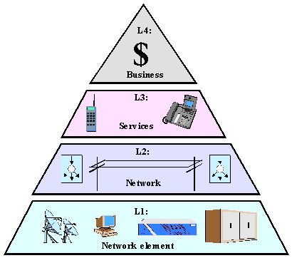
The hierarchy of management systems can be divided into a sequence of 4 layers in correspondence with goals of services (fig. 1).
First layer L1 is used for implementation of network elements (NE) management using own internal agents or external agents built as Q-Adaptors.
Second layer L2 is used for management of networks resources as a result of controls gotten from layer L3 from services management or from fault messages analysis gotten from agents of layer L1. The activity from layer L2 results in modifications of performance, capacity and topology and other parameters of networks under management.
Third layer L3 disposes to users all the spectrum of own and external telecommunications services.
Fourth layer L4 deal with strategic plans in development and using of telecommunication resources and services.
Objects under management in Hunedoara County (Romania)
Hunedoara County owns a complex set of telecommunications resources of national and regional level. Geographic position of County in Romania is shown on fig.2. On the surface of 7,025 square km there are about 0.55 millions inhabitants distributed in next proportion: 71 % lives in urban regions and the rest of 29% - in rural one.
Fig. 1. Hierarchy of layers of telecommunications management
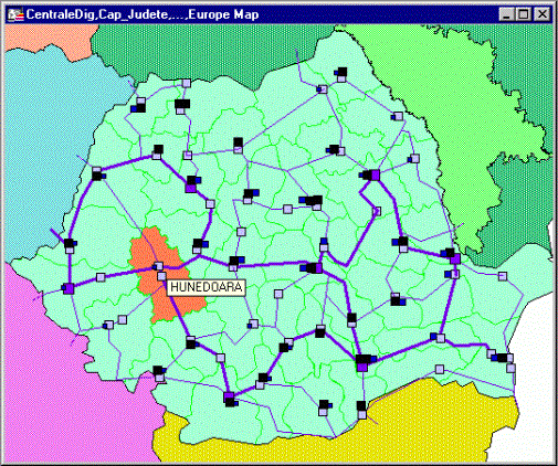
Fig. 2. Position of Hunedoara County in National Telecommunications system
The infrastructure of telephonic services in 1999 can be characterized by next statistical data:
Lines set up: 85 115
including: analog 28 470 urban 23 600 rural 4 870
digital 55 000 urban 52 500 rural 2 500
manual 1 645 urban 140 rural 1 505
Occupied lines: 71 530
including: analog 25 019 urban 20 51 rural 3 846
digital 44 843 urban 41 996 rural 1 799
manual 1 668 urban 143 rural 1 492
Public access points: 855 subscribed 31 cards 824
All managed objects from Hunedoara County can be divided in next categories (fig. 3):
Fig. 3. Telecommunications objects in Hunedoara County
· Transmission system (TS), having transport channels and channel-level operation equipment:
- fiber optics national backbones BB1, BB3 : 288 km;
- regional rings of fiber optics TIM1,TIM2 : 157 km;
- Local fiber optics lines: 197 km.
- STM16 (Philips);
- STM4 (Philips, Fujitsu);
- STM1 (Alcatel);
- PDH (Alcatel, Ericsson);
- Symmetric cables: 680 km;
- Analog circuits: 1066 (33%);
- Fiber optics cable: 360 km;
- Digital circuits: 2170 (66%).
· Switching systems (SS), formed from Exchanges, satellites, hand switched operator assisted nodes, local distribution systems having integral capacity of 89900 units and 71500 connected lines:
- 9 digital exchanges ("Alcatel" - 3 with 13 satellites, "Ericsson" - 2, "Topex" - 3, "Goldstar" - 1), 62400 served units;
- 30 analog exchanges ("Pentaconta" - 9, "Topex" - 3, "Pentomat" - 18), 25800 served units;
- 8 hand switched exchanges, 1700 served units.
The management system for such complex set of telecommunications objects is hierarchical having four level of management (fig. 4).
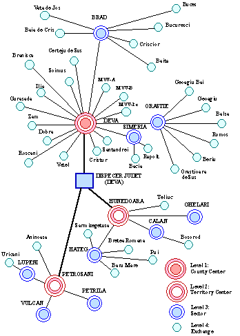
Fig. 4. County-level hierarchy of telecommunications management
General structure of Regional TMS
Automated and integrated management system is capable to improve all the complex of processes of coordination of resources necessary for supervision, monitor, projection, simulation, generation, implementation, analysis, measurement and test telecommunications networks in order to warranty to end users high level of services, at adequate price and optimal distribution of capacities.
The structure of Regional TMS for Hunedoara County is based on generic model of TMN recommended in ITU-T standards of series M (fig. 5).
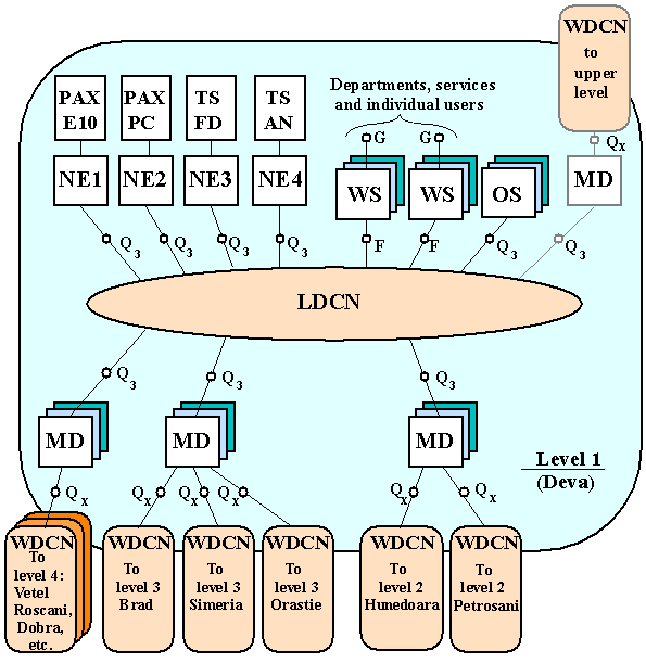
Fig. 5. Regional Telecommunication Management System structure
RTMS includes next components:
· LDCN and WDCN are Local and Wide Area Digital Communications Networks.
· OS are Operations Systems
· WS are workstations
· MD are Mediation Devices
· NE are Network Elements (and Q-Adapters)
· PAX are Public Automated Exchanges
· FD and AN TS are Fibres Digital and Analogue Transmission Systems
Objects under management are equipped by monitor and management agents mounted on NE and connected to OS and WS via LDCN or WDCN. Data transport is made using Distributed Component Objects Model (DCOM).
WDCN has star-ended linear fibre optic ATM backbone having 155 Mbps throughput (fig. 6.).
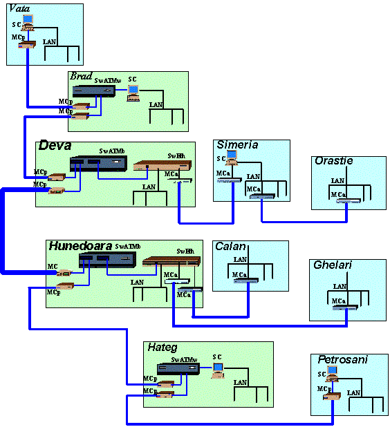
Fig. 6. Wide Area ATM Backbone DCN topology
Software of regional TMS is distributed over LDCN and WDCN servers, databases and workstations and has also hierarchical structure shown on fig. 7:
· TMNC is TMN Software of County level
· TMNT is TMN Software of Territory level
· TMNL is TMN Software of Locality level
System software is based on MS Windows NT platform, MS SQL database systems, Delphi programming environment and MapInfo GIS. Most kinds of information are available via Intranet Web services, that implements WBEM (Web Based Enterprise Management) paradigm.
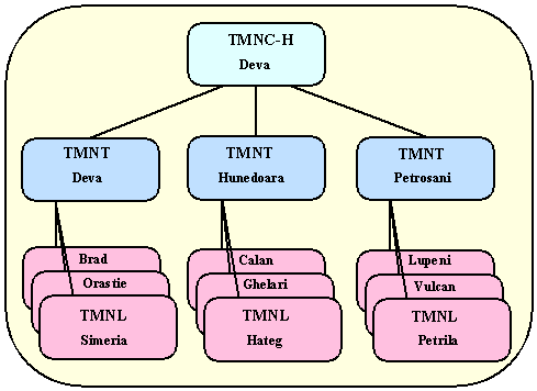
Fig. 7. Hierarchy of Management software systems
Internal structure of TMN software can be presented on abstract level, shown in fig. 8.
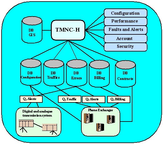
Fig. 8. The structure of Regional TMN Software System
Figure 9 illustrates samples got from main management services:
· Performance management;
· Fault management;
· Configuration management;
· Account management and
· Security management.
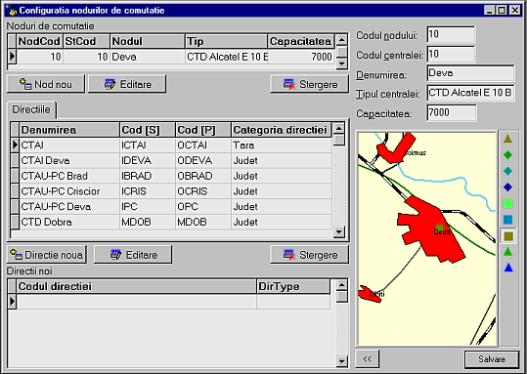
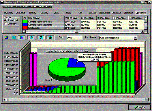
Fig. 9.Configuration and account management screen samples.
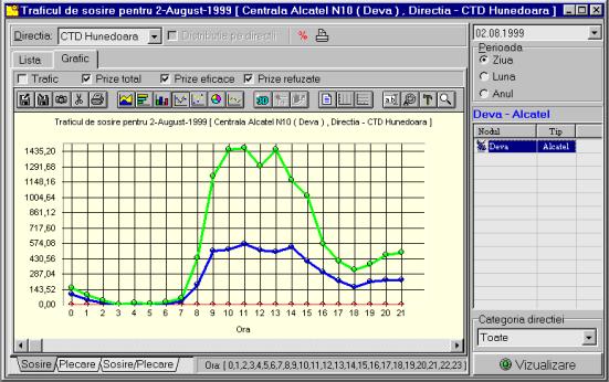
Fig. 10. Performance management system screen sample
Conclusion
DCOM and WBEM based Telecommunications Management system with Interactive Geoinformation sub-systems incorporated into TMN architecture gives the possibility to significantly increase integral efficiency and spatial accuracy of management procedures. Networks under management configuration and current state monitoring become spatially "natural" for managers. They can easily browse inside managed object space. GIS also provides good possibilities for networks topology optimization and future planning